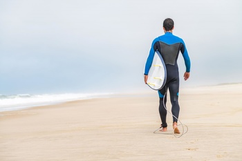
Going out to sea on a yacht without thinking about the weather forecast may not be a safe idea. For those who are just beginning their journey into the world of yachting, Anastasia Nosova from Windy.App, the weather app for yachtsmen, has prepared a little talk about the nature of the wind and how to learn about the impending storm from the clouds.
How the wind appears.
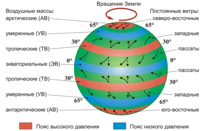
Before we talk about wind, we need to get acquainted with the concept of air mass. This is what they call a large volume of air several kilometres thick with approximately the same temperature and humidity. Horizontally, the air mass spreads over several thousand kilometers.
The laws of physics are arranged so that changes in pressure and temperature in gases are closely related. In areas where the air heats up more, the pressure is lower. And vice versa. The air masses always tend to move from areas with higher pressure to areas with lower pressure. This is the movement of air relative to the earth's surface we call the wind.

Where the wind blows.
On the map, the points where the same atmospheric pressure is fixed are connected by lines - isobars. The air tends to move to the low pressure zone along the shortest path - at right angles to the isobar. This perpendicular is called normal.
The pressure drop is the only thing that gives the air acceleration. The faster the pressure changes from place to place, the higher the wind speed. All other forces, such as friction, only reduce the wind speed and/or change its direction.
The wind would have been directed simply perpendicular to the isobar if the Earth had not been spherical and revolved around its axis. However, this is not the case and all moving objects, including the wind, are affected by the so-called Coriolis force. It is one of the most noticeable forces that affects the direction of movement of air masses. It deflects the wind from normal to some angle. In the northern hemisphere, the air is twisted clockwise (to the right) and in the southern hemisphere it is twisted counterclockwise (to the left) relative to the direction of movement.
As there is less air friction over the sea against the surface, this deviation is expressed more strongly. If over land it is usually 40-50°, then over the sea it can reach 70-80°, and then the wind blows almost along the isobar.
How do you measure wind speed...
Wind measurement devices are installed 10-12 meters above the ground surface. To convert wind speed from meters per second (m/s) to nodes (nautical miles per hour), multiply the value by 2.
Wind speed is sometimes rated on the Beaufort scale: 0 points for Style and 12 points for Hurricane. Wind speed in this system is associated with the effects of wind, which can be seen with the naked eye: the excitement of the sea, swaying branches of trees, the spread of smoke from pipes.
When indicating the direction of the wind, they call the side of the light from which it blows. Less often, the direction is indicated by an angle:
- 0° and 360° - North;
- 90° East;
- 180° to the South;
- 270° West.
Cyclones and anticyclones...
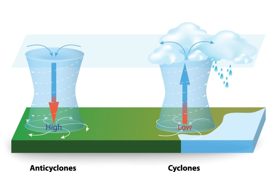
The main elements in the system of air currents on Earth are waves and vortices of several thousand kilometers in size that constantly arise and break down in the atmosphere. Those vortices in which the area with the lowest atmospheric pressure is in the centre are called cyclones. If, on the contrary, the vortex has the region of the highest pressure in its center, it is called an anticyclone.
Remember that air tends to move from high to low pressure area. Due to this cyclone is a whirlpool, in which air is conditionally sucked into the center, and in the anticyclone on the contrary - blows out of the center.
The region of the lowest pressure is located in the center of the cyclone and at the periphery of the anticyclone. That's where the strongest winds will blow.
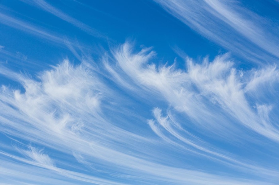
The approach of the cyclone is evidenced by the appearance of thread-shaped pinnate clouds on the horizon, which move in parallel strips. Over time, the sky is tightened by denser and lower clouds.
Fronts
The area where two air masses collide at different temperatures is called the front. Because the cold and warm air masses are at different altitudes in the atmosphere, the fronts are not perpendicular to the ground but at an angle. When the air masses collide, one of them seems to crawl on the other or, conversely, climb under a neighbor from below.
If you have a front ahead of you, expect a change in weather and rainfall. If warm air moves forward, this front is called warm; if cold, this front is called cold.
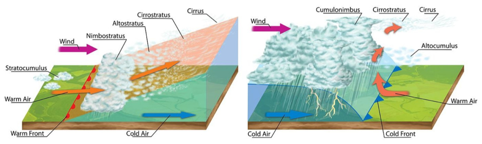
Warm front
The warm air mass, passing over the cold, gradually cools down. However, cooling is slow, so instead of saturated but short showers you get prolonged drizzling rains or shallow snow in winter.
Cold front
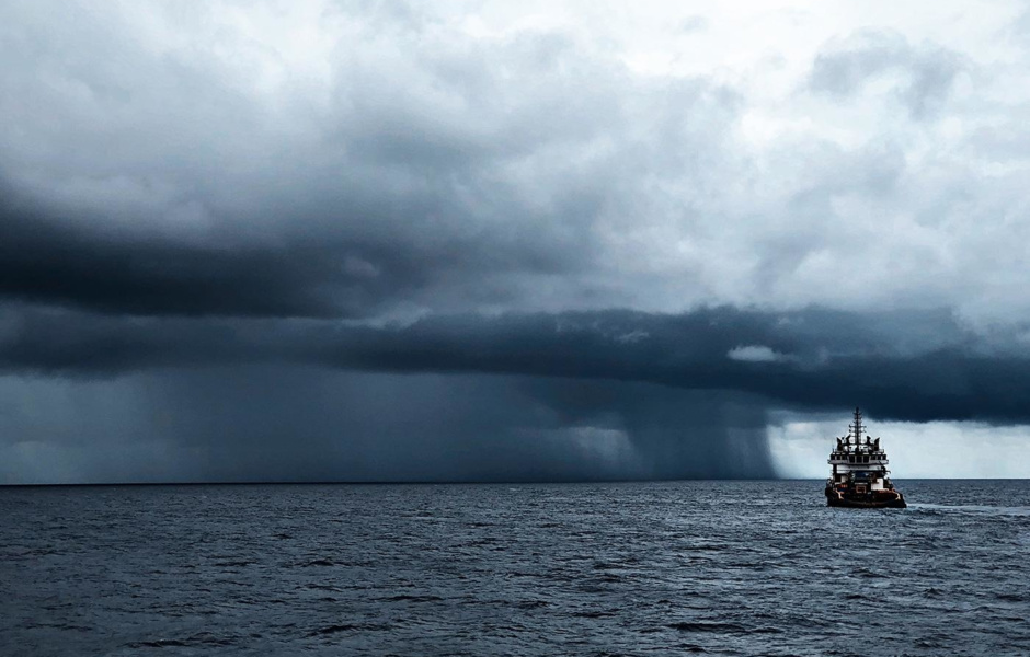
Moving over a warm surface, the cold air mass warms up itself, faster than a warm front would. The moist and warm air displaced upwards, in turn, cools sharply, forcing the water in it to condense into the powerful cumulus-rain clouds carrying with them heavy downpours and thunderstorms.
In young cyclones, there is warm air between the warm and cold fronts at the surface. This zone is called the "warm sector". The warm and steady air mass in this zone usually brings mists and drizzle to reduce visibility. Although there may be heavy rains and thunderstorms above the land in a warm sector in summer. As a cyclone evolves, this zone gradually shrinks until it finally disappears near the Earth's surface.
The front of occlusion
When two cyclones collide and connect, a fast moving cold and slower and warmer, an occlusion front (closed front) occurs. Thus, three air masses of different temperatures interact in the area of this front at once: two cooler ones that are closed at the bottom, and a really warm one that is displaced upwards by them. This naturally leads to rainfall of varying intensity and thunderstorms.
Breeze
During the day, the sun heats the land more than water. And at night, the land cools down faster than water. So warmer air is above the land during the day and over the sea at night.
During the day, light hot air rushes upwards over the land. But its place is not empty: by lowering the pressure in this area, cooler air from the sea immediately rushes into it. At night, when the air above the land cools down, the wind reverses.
Usually wind speed at breeze is 3-5 m/s. In the tropics, due to the greater temperature difference between land and sea, it can be even higher.
What will the clouds tell you
The shapes of the clouds are very diverse. There are whole atlases of photographs with descriptions. However, there are only ten main cloud shapes. And you have to worry that the rains will start soon when you come across three of them:
Layered rain .
This is the name of the dense cloud cover of dark gray color, through which the sun and moon do not even shine. Under them often gather shapeless clusters of low torn clouds, especially dark against the background of layered rain clouds, which are also called "clouds of bad weather. The name of these clouds speaks for itself. They are the ones that bring average rain or snowfall, which lasts about 10 hours and falls over a large area.
Layered
These clouds represent a homogeneous but thinner gray layer of droplets, similar to the fog hanging high above the ground, through which the Sun and Moon clearly shine. Sometimes these clouds have the form of torn scraps (torn-layered clouds). From them drizzle, ice needles, fine snow, snow grains can fall out.
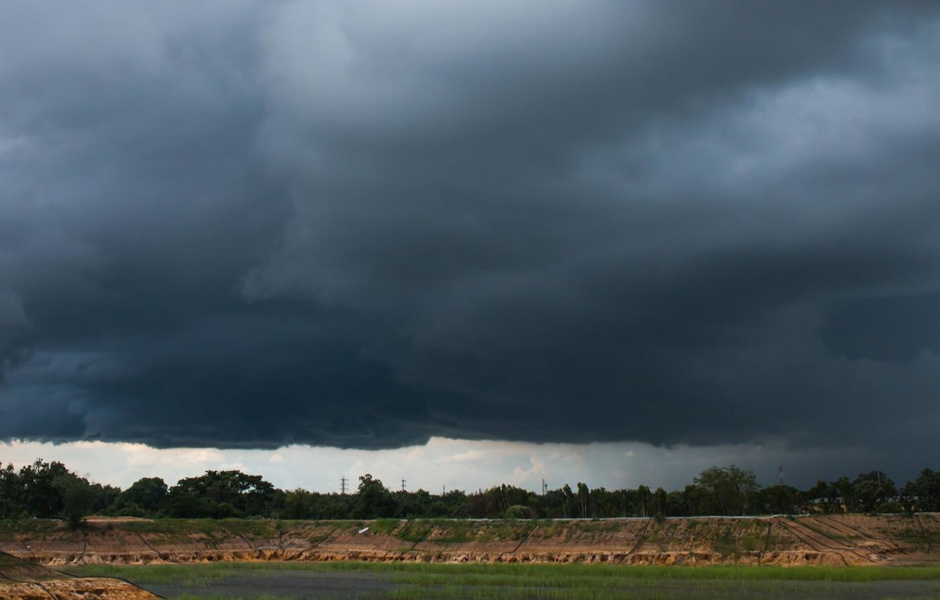
Heap-rain clouds
These are powerful, vertically developed cloud masses in the form of mountains and towers. Their peaks are flattened and often have the characteristic shape of anvils. They are harbingers of downpours and thunderstorms. The good news is that in contrast to heavy rainfall, the rains, though intense, are short-lived. It is against the background of these clouds you can admire the rainbows.
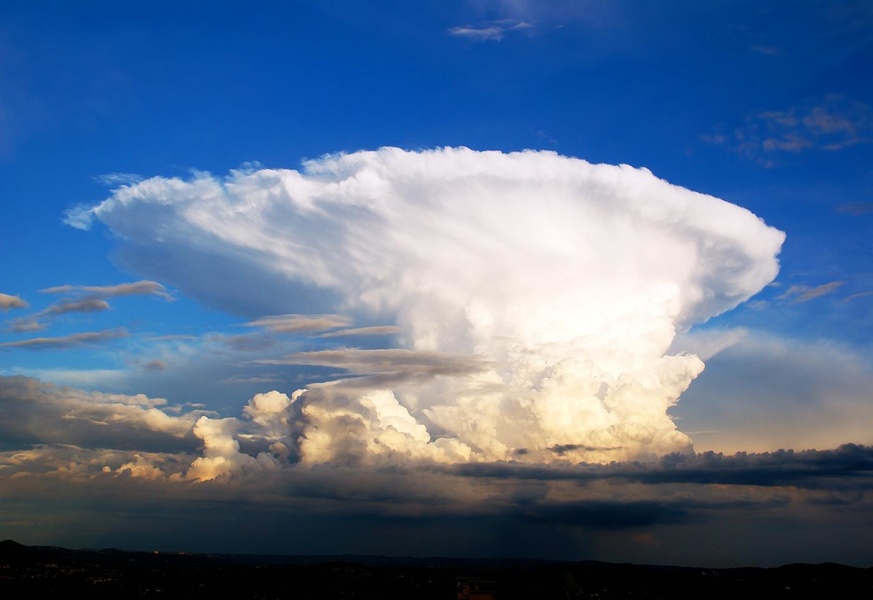
With the heap-rain clouds associated with such a phenomenon as squall. This is the name given to a sharp short-term wind gain of 20 m/s or more, accompanied by a change in wind direction. Such amplification lasts several minutes and sometimes repeats itself for a short time.
The squall cloud has a very characteristic appearance: it is black, with torn edges like claws going down and a white rain curtain at the depth of the cloud. The cloud goes low above the ground; its lower edge changes its shape every second.
If the crew doesn't get ready for the squall in time, he may tip the boat over. If the wind starts to calm down as the heap clouds approach, the signal is to act quickly. Soon it will blow again, but in the opposite direction. As a rule, a squall catches up with the boat as soon as the cloud is over it. By that time, the sails must be cleared.
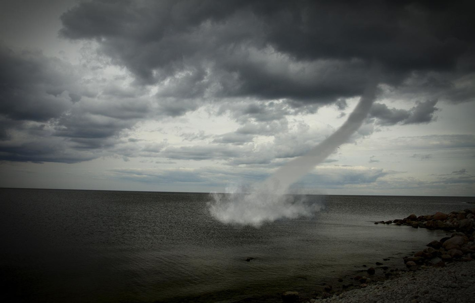
Besides, tornados are connected with heap-ain clouds. They are often formed in series of several vortices in front of the thundercloud and penetrate from above to the earth's surface. The diameter of the tornado is about tens of meters. From the side, it looks like:
- a dark column between the clouds and the water, expanding upwards and into the book;
- or like a trunk hanging from a cloud.
The vortex moves together with the cloud at a speed of about 30-40 km/h. Its time of existence is measured in minutes, but during this time it can move several kilometers over the sea. Deaths are less destructive than land-based tornadoes, but they must still be avoided.
The winds are atmospheric assistants and enemies at sea.
Passages
Near the equator in both hemispheres there are belts of constant east winds - passats. Their speed near the Earth's surface is on average 5-8 m/s. Above the trade winds zone layered clouds are formed, so precipitation is not frequent here.
The band above the equator itself, located between the Passat belts, is called the intra-tropical convergence zone. This low atmospheric pressure zone is 1-3° wide along the meridian.
Its position relative to the equator varies slightly depending on the season. It shifts slightly to the hemisphere in which summer comes.
The weather in this zone is unstable: periods of drought with weak winds and even calm are replaced by showers and squalls, which last for 2-3 days.
Tropical cyclone (typhoon)
Meteorologists pay particular attention to the observation of powerful cyclones that form in the tropical zone between 5 and 20 degrees latitude in both hemispheres. It looks like a giant storm cloud, into which spiral ridges of clouds are drawn.
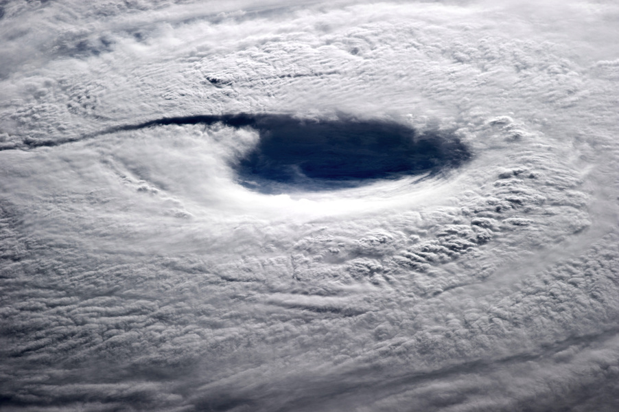
In such a cyclone, the wind increases to 17 m/s or more. In one case out of ten tropical cyclones develop into a storm with winds up to 33 m/s or even a hurricane at gusts over 33 m/s. On average, the wind speed at the Earth's surface is 40-50 m/s with individual gusts of up to 100 m/s.
In total, about 80 tropical cyclones with storm and hurricane winds occur on the Earth per year. The main reason for their occurrence is a powerful rise of heated and humid air over a large area of the ocean. Above land, they never form.
Passing through, a tropical cyclone causes great excitement at sea. Flat shores flood waves up to 10-15 meters high.
Most tropical cyclones travel along similar trajectories. It resembles a parabola with its peak facing west.
Passing into temperate latitudes, a tropical cyclone expands in area, but this becomes the beginning of the end for it. Pressure drops between the central region and the periphery become smoother, and wind speed in the cyclone drops. It is losing its destructive power.
Bora
Another type of strong cold and gusty wind is called boron. When the cold air passes over a low mountain range, reaching the warm sea at the foot, it accelerates to significant, stormy speeds and causes strong excitement. The boar does not stop for 1-3 days and sometimes even a week.
What kind of boar can a boar be and where it blows:
- The northwest wind is the Mistral, which blows from the northern parts of Europe along the valley of the Rhone River in the Gulf of Lyon in France, from Montpellier to Toulon in February-March.
- The north and northeast winds like the bora in Spain, France and even Italy are called Tramontana.
- From Canada to the United States, Mexico, the Gulf of Mexico, all the way to the north of South America, in November and April, Norther blows.
- The Adriatic borax in Croatia and Montenegro is also called Bura. In winter, it can cover almost the entire Adriatic Sea.
- Strong borax can be found in winter on the Black Sea near Novorossiysk.
- Northern Khazri blows in the Caspian Sea near Baku city in Azerbaijan.
Where yachtsmen learn meteorology
- Specialized literature:
- Frank Singleton. Reeds Weather Handbook
- Steve and Linda Dashew. Mariner's Weather Handbook
- Commander C.R. Burgess. Meteorology for seafarers
- Larry Lawrence. Marine meteorology
- Video lessons on Youtube:
- 1.5-hour lecture Weather for Sailors by Maryland School of Sailing
- Weather checklist from the Australian Bureau of Meteorology
- Yale University course in meteorology
- Online courses:
- Strategies for winning. Meteorology in a round the world regatta
- Wind resources for renewable energies
- Come Rain or Shine: Understanding the Weather
World universities offer full academic online courses on meteorology. For example, in the British The Open University can take a six-month course Science: the weather, paying about 180 euros.