Last time we were talking about navigation applications for yachting. Now let's talk about the weather.
What is a weather application? It is a program that visualizes weather data downloaded as a GRIB file. Most of the applications resell free GRIB files that the US National Oceanic and Atmospheric Administration uploads every 6 hours to FTP.
The computer model used by Americans for weather forecasting is called the Global Forecasting System (GFS).
As the name suggests, it is global and therefore does not take into account such «trifles»as thermal winds, breeze from land and sea, topographic aspects.
By default, the GFS forecast resolution is 0.5 degrees. This means that the square size of its coordination grid is 0.5 degrees of latitude by 0.5 degrees of longitude (about 50×50 km). At 100 nautical miles from shore, the GFS forecast is likely to be fairly accurate, but near the coastline it may differ from reality.
If the application uses a local model as the data source, the forecast for that area will be more accurate. But you should not wait for something supernatural. Any GRIB file is a computer calculation, there is no place for the forecasters to interpret it.
In most cases, the forecast will underestimate the strength of the wind. For example, wind speed is usually considered 10 meters above average sea level. If the mast height of a sailboat is more than 10 meters, you need to add 20% to the forecast wind speed. In gusts, the wind speed will increase by another 20%.
One GRIB supplier, Saildocs, warns that computer models grossly underestimate the power of hurricanes because of their small size relative to the coordination grid. Although the GRIB file will provide useful data on the likely path of a hurricane, one cannot rely on it alone: one must follow the warnings.
It is also useful to remember a few rules:
- By nightfall, the wind always subsides and during daytime it increases.
- The wind will blow along steep coasts and around capes, not over them.
- The pressure above the ground increases at night, cooling off the offshore winds.
- Ground pressure drops during the daytime, heating the sea breezes that are forming.
- A slow drop in pressure means that it is likely to rain a little and the wind is weak.
- A moderate pressure drop means moderate wind and rain in a warm front.
- Rapid pressure drop - high probability of storm.
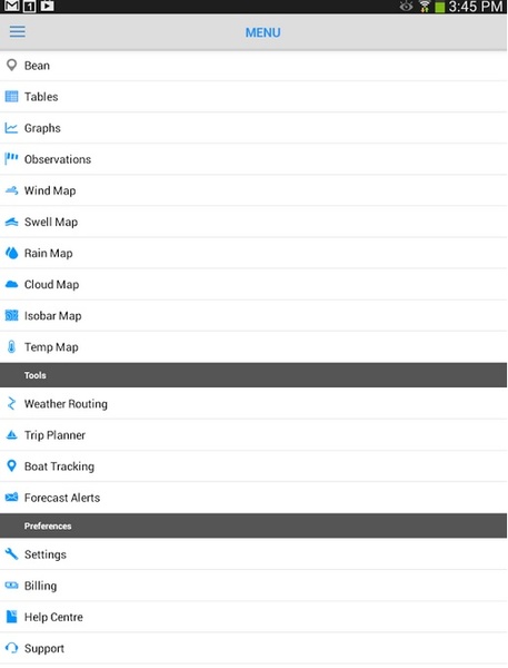
Knowing the limitations of weather applications, you can use them much more efficiently. Below we'll list some popular programs. Choose the most convenient for you and use them with pleasure.
PocketGrib (iOS, Android)
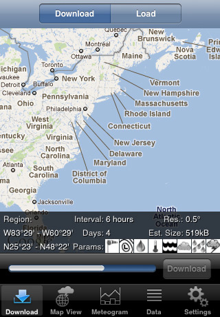
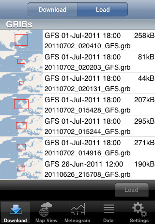
One of those applications that resells free GRIB files to Americans. When you first get acquainted with the program, the start screen informs you that you do not have any downloaded GRIB-files. To correct the situation, click on «+» in the upper right corner of the screen. The application will prompt you to select a geographic area. There are two ways to do this: to mark it on a map and find it in the catalogue. After that you can set up a forecast: set the duration, step, resolution and choose what data you want to see. The free Lite-version provides a forecast of wind strength and direction, precipitation and atmospheric pressure for a maximum of two days in 6 hour increments. In the paid version, the forecast is eight days, the minimum step is 3 hours, and in addition to these parameters, there are wave height, cloudiness and relative humidity. It costs 4 bucks for Android, 5.99 - for iOS.
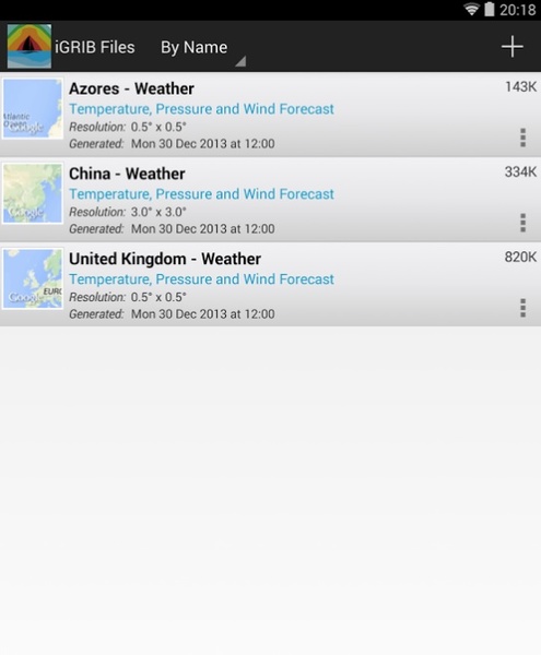
After setting the GRIB-file is downloaded to the phone memory for offline use.
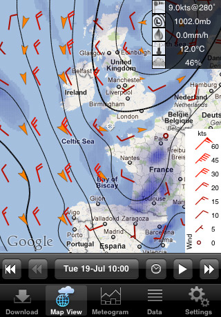
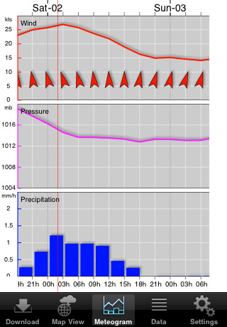
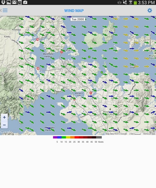
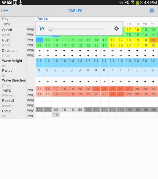
Meteodata is provided in three formats: superimposed on the card, in charts and in a table.
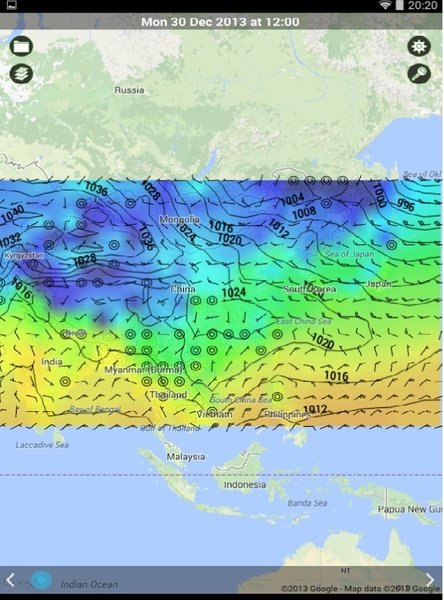
Winds are indicated by standard arrows on the map, pressure by isobars, and precipitation levels by darkening various shades. One click on the map gives you a hint in case you forget what it says. The «play icon at the» bottom of the screen includes an animation showing how the weather changes over the predicted time period.
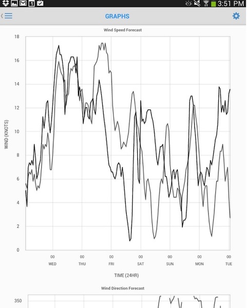
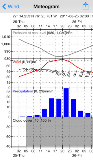
The metogram displays a graph of changes for each weather parameter. It's handy when you need to quickly get an idea of any - even the smallest - changes in the weather.
In the settings, you can specify in which units to show the forecast: nodes, kilometers per hour, miles per hour or on the Beaufort scale for wind speed, degrees Celsius or Fahrenheit for temperature, pressure in millibars or inches of mercury column.
iGrib (iOS, Android)
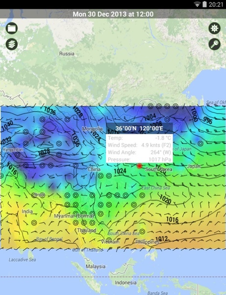
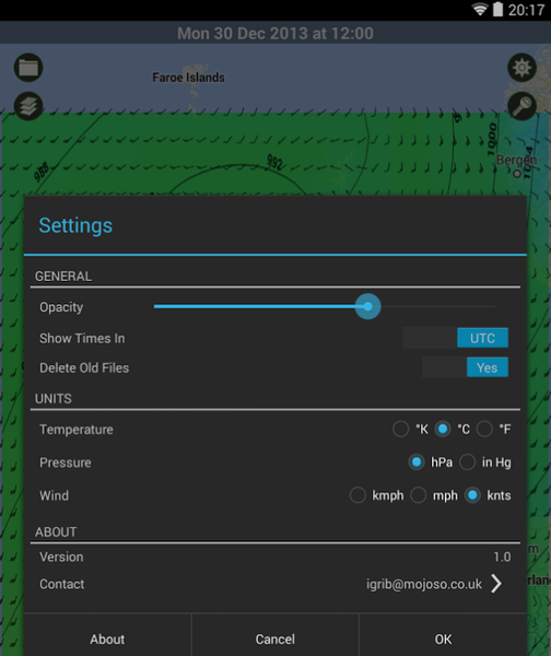
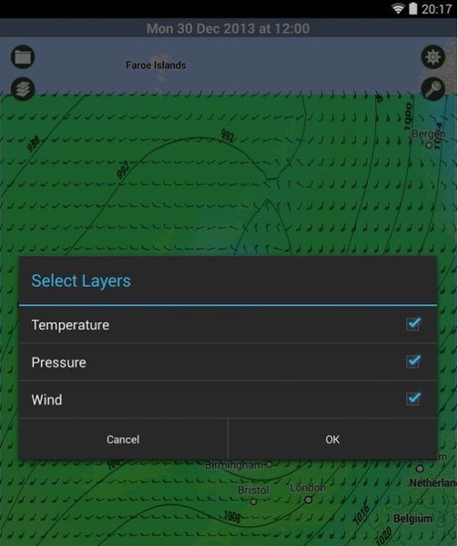
Works on the same principle as PocketGrib, that is, downloads GRIB-files from the GFS server and applies them to the card. The data set is standard: wind strength and direction, wave height, air temperature, precipitation, cloudiness, atmospheric pressure. The forecast is ten days at most. There is only one format for providing data: overlaid information layers that can be selectively turned off and their transparency level changed. Clicking on a certain point on the map will cause a window with weather values in that place. As in PocketGrib, you can set up units of measurement.
The graphics in iGrib are a bit better than in PocketGrib. However, the most significant advantage of the former is the ability to download GRIB files from third-party services, not just GFS. iGrib is paid - unlike PocketGrib, it does not have a lite-version. The price of the application for Android is $6.99, for iOS - $5.99.
Windfinder (iOS, Android)
Forecasts of the free version of this application are traditionally based on GFS data. The horizontal resolution is about 27 km. The paid version adds local models for Europe, North America and Egypt to the global GFS model. The resolution of the European and North American models is 12 km and that of the Egyptian model is 7 km.
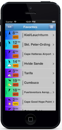
The start screen of the application shows a list «of selected» locations with the current speed, wind direction and air temperature in those locations. There are several ways to add a geographic location to your favorites: by allowing the application to automatically determine your current location using GPS, by entering the name of the nearest settlement, or by performing a list search.
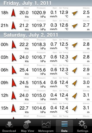
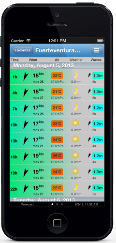
Clicking on one of your favorite locations opens a detailed forecast for 7 days in 3 hour steps. In the paid pro version the hourly forecast is available, but only for three locations. The forecast includes data on wind force and direction, air temperature, precipitation, wave height and tidal currents.
Interestingly, there is even information on wind speed in gusts, which is quite rare in weather applications.
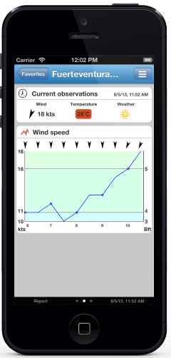
The«Report»»screen «shows a graph of wind force and direction changes for the selected location over the last 12 hours. It allows you to quickly track the trend, for example, the graph below shows that the wind was increasing during the day.
The paid version has a widget that you can install on your home screen to get the weather forecast at your favorite location without opening the application. It's a pretty handy feature. And the best part is that the app costs only $2 for both Android and iOS.
PredictWind (iOS, Android)
PredictWind has two data sources, GFS and CMC (Canadian Meteorological Service model). According to the authors of the application, they developed their own weather forecasting system that takes into account the terrain.
The
free version of PredictWind includes
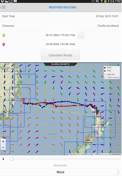
a 7-day hour forecast of wind direction and speed, air temperature above water, altitude, frequency and direction of waves, precipitation and cloud cover with a resolution of 100 km. You can only see the weather at three predetermined points at the same time. The map in the free version is for winds only, the rest of the information is provided in tables and graphs. Wave maps, water surface temperatures, rainfall and cloud maps are available in paid versions. The most expensive, professional, offers very good resolution in 1 km.In addition, the paid versions have GPS tracking, which allows family and friends to track the location of the ship, and tools for weather planning - plotting the fastest route and calculating the most successful departure date.
One of the most interesting features of Predictwind is the ability to transmit GRIB files via satellite, which makes it indispensable in long offshore locations when there is no internet connection.
Not for nothing among professional users of PredictWind - tactician Emirates team NZ Ray Davis and the winner of the Cup of «America» 2003 navigator Andrew Cape.
The main disadvantage of PredictWind, in addition to a rather complex, graphics-rich interface, is its pricing policy. For the professional version you will have to pay $199 for three months or $499 per year. However, for day trips to the sea, fishing, coastal cruises, windsurfing the free version is enough for your eyes.
Weathertrack (
iOS
)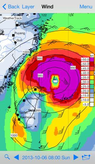
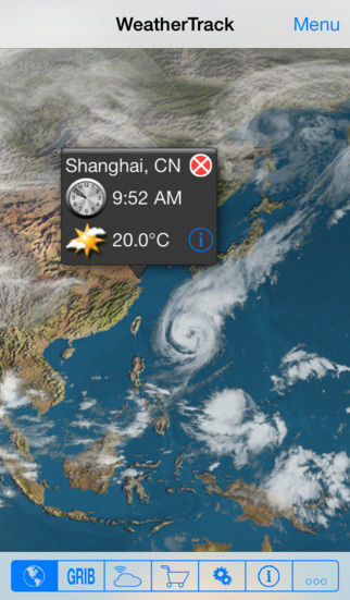
This application downloads GRIB files from a variety of sources: the American GFS, the Cyprus Center for Oceanography, the Norwegian Meteorological Institute, Tidetech (data provider for the America»'s Cup «and Volvo Ocean Race 2011), the non-profit organization Sailmail and the German Federal Office for Maritime Affairs and Hydrography.
Like PredictWind, it can receive updates without an Internet connection by updating via satellite.